
Jo Caird visits Haida Gwaii off the Canadian coast

Photo by Steve Pretty
Jim Hart, one of Canada’s leading First Nation artists, is midway through telling me about his current project, a totem pole that will stand in the grounds of the University of British Columbia, when the phone rings. Hart’s wife Rosemary answers it, lets out a squeal and rushes to the balcony at the back of their longhouse-cum-artist’s studio.
There in the bay, glossy and black against the choppy grey water, are a pair of orcas, a mother and calf by the looks of it. Not every whale sighting would warrant a phone call between neighbours here in Old Massett, the most northerly settlement of the Haida Gwaii archipelago, off the coast of Canada close to where it meets Alaska. But these animals are special: the first arrivals of the summer season in this remote and wild place.
Related


We watch them for a while, but it’s not long before I’m lured back into the longhouse by the promise of hot coffee. It was 32°C in Vancouver, where I spent the weekend getting over my jetlag before hopping on a prop plane for the 460-mile journey north-west, but summer is a different story in this part of the world. A chill wind blows down from the Gulf of Alaska and the June sunshine is frequently obscured by banks of ominous black clouds.
Hart’s people, the Haida, like other indigenous groups across North America, have not had an easy time of it. But after they were almost wiped out in the 19th and 20th centuries by a double whammy of disease and forced assimilation, things are looking up. In the 1980s, following protests against commercial logging that was fast destroying this beautiful wilderness, the Haida took back control over lands they have occupied since around 10,000 BC.
The Gwaii Haanas National Park Reserve and Haida Heritage Site was established soon after, and in 2010 the name of the archipelago was changed from the colonial-era Queen Charlotte Islands to Haida Gwaii (Islands of the Haida People).
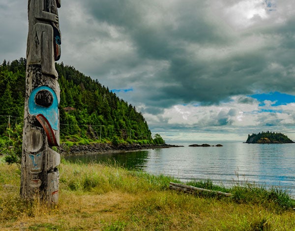
Old Massett may occupy a stunning spot here on the bay, but as a village it’s not exactly picturesque. There are high levels of unemployment and deprivation among the island’s Haida community and it shows in the run-down state of the property here (with the notable exception of the Harts’ longhouse, which is beautiful). What makes Old Massett an essential stop on any Haida Gwaii itinerary are the village’s totem poles, the largest collection on the islands.
Content from our partners


I wander through the village, armed with information from the excellent Haida Heritage Centre at Skidegate (the location of the other major Haida settlement). House frontal poles, memorial poles and mortuary poles, which incorporate grave boxes into their designs, tower over me, some of them up to 20 metres tall. The most common symbols carved into the strong, rot-resistant red cedar trunks are those relating to the natural world — highly stylised eagles, orcas and bears that connect 21st-century Haida people to the land and culture of their ancestors.
To really get a sense of that culture, you have to get out into the landscape that informed it. Leaving Hart to get back to work on the enormous tree trunk in front of his property, I set out for Tow Hill, a viewing spot overlooking a creek at the north-east corner of Graham Island. I’m glad of the four-wheel drive on my car as the paved road gives way to a bumpy track through a forest so dark and dense I have to turn on the headlights. Thick, wet garlands of moss hang heavy from the branches above.
The trail, when I finally reach it, is surprisingly well equipped: signs bearing information about the area, benches and even a wheelchair-accessible boardwalk along the creek at the edge of the forest.
Tow Hill is swaddled in mist, obscuring the view, so I head straight to the dark, shingly beach it overlooks. Hoof marks point to the recent presence of members of the islands’ deer population, and the call of ravens provides a harsh soundtrack to this bleak, drizzling scene. Every so often, sea water is forced up through a crack in the rocks lining the shore, forming a natural blowhole that Haida legend says belonged to a passing whale that was turned to stone.
As soon as I’m out of the forest the weather improves, and by the time I’m speeding back towards the village of Queen Charlotte, it’s turned into a glorious summer evening. I’m tempted to pull over for a stroll, but I push on: tomorrow is an early start.
There are 600 Haida archaeological sites along the coast of Haida Gwaii, but just five historic villages are open to visitors today, accessible by boat, sea kayak or chartered seaplane only. Not being in possession of my own yacht, and lacking the upper body strength for an extended journey by kayak, I opt for a day trip with Moresby Explorers via RIB boat to the closest of the Haida heritage sites, K’uuna Llnagaay (aka Skedans).
After 45 minutes of bumpy road on Louise Island we reach Moresby Camp, once a logging station that’s now the gateway to the national park. I’m sure I’ll be too warm in the waterproofs, wellies, life jacket and woolens provided for the RIB ride, but I’m proved wrong almost the minute we set out. The wind in the channel is bitter.
Our first stop is Aero Camp, where logs for the production of Mosquito bombers were once dumped at the shore by steam train, ready to be floated down to the Canadian mainland. All that’s visible now from the boat are the vegetation-covered pilings of the camp’s abandoned pier, home to loudly chirruping pigeon guillemots and other migrating sea birds.
Another former logging camp, a little further on at Mather’s Creek, is even more atmospheric, having been abandoned in a hurry after the end of the Second World War. The bulky iron machinery, deemed too heavy and outdated to take back to civilisation, is impressive, but it’s the bottles and leather boots piled up on the mossy forest floor that I find most affecting.
A short walk beyond the camp is an overgrown cemetery dating back to the late 19th century, a clue to the fate of the Haida people in this area. The names on the higgledy-piggledy marble gravestones are Christian ones, but the remains are of Haida people, a community decimated by smallpox epidemics.
Smallpox led to the eventual abandonment of K’uuna Llnagaay, the final stop on the tour, too. As more and more members of the community died, village life became unsustainable and people collected into new communities to pool resources, ending up in just two settlements, Massett and Skidegate. By the turn of the century the Haida population had fallen from as many as 20,000 across the archipelago to just 600.
Our skipper calls ahead to ask permission of the watchmen — or, as it turns out in this case, women — to land at K’uuna Llnagaay. Haida people are stationed in each heritage village to limit visit numbers and ensure these sacred spots are protected. We pull up on the beach in a protected bay. Once upon a time it was encircled by longhouses, their frontal poles visible to approaching vessels, but the longhouses are long gone, mere pits in the ground now, and the poles that remain are obscured by trees.
It’s not frontal poles that I find in K’uuna Llnagaay, in fact — those have all been rescued from the elements and now mostly abide in museums — but memorial and mortuary poles, left to return to the earth as part of the natural cycle of birth, growth and death. It’s very hard to make out the symbols on the badly deteriorated sculptures, but once I get my eye in I recognise potlatch rings signifying a chief’s wealth, a pair of eyes, one side of a mouth full of teeth. It won’t be long before these details disappear too.
The group is very quiet on the journey back from the village, past a dozen islands, some little more than tree-covered rocks in the sea, some large enough to have attracted the attention of unscrupulous commercial loggers in the 20th century and still bearing the scars today.
The forests within the Gwaii Haanas National Park Reserve and Haida Heritage Site are now protected, of course. Logging still goes on across the rest of the archipelago — but these days it’s managed by the Haida Nation and is done so sustainably. The land, just like its people, is undergoing a process of recovery, after many years of ill treatment. As we make our way around the far side of Louise Island, through a channel so narrow it’s only passable at high water, everything is green and grey, as far as the eye can see.
Back at the B&B that evening, I watch a pair of bald eagles swoop through the air, bickering over territory perhaps, or involved in some sort of mating ritual. They’re joined by a third, then a fourth, then a fifth, then suddenly there are eagles everywhere I look, twelve of them wheeling and squawking in the fading light. I’m the only person around to see it.
Jo Caird visited Haida Gwaii as a guest of Destination British Columbia
hellobc.co.uk
EASY BC
-
Getting there: Air Canada flies to Sandspit, Haida Gwaii, from Vancouver
aircanada.com -
Getting around: Budget Car Rental has offices at Sandspit Airport and in the village of Queen Charlotte
budget.com -
Where to eat: Haida House, Tlell
haidahouse.com
Kay Bistro, Haida Heritage Centre
haidaheritagecentre.com -
What to do: Moresby Explorers arranges day tours and multi-day trips to the Gwaii Haanas National Park Reserve and Haida Heritage Site
moresbyexplorers.com
Haida Heritage Centre
haidaheritagecentre.com